10 hours; climb: 1600m
A long, hard mountain route which takes you up to glorious ridges and summits in the Canigou massif.
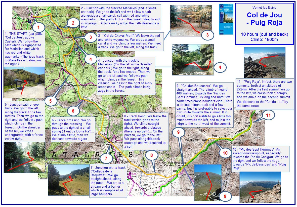
1 - THE START (car park, 'Col de Jou', above Casteil). We follow the path which is signposted for Mariailles and which has red-and-white waymarks. (The jeep track to Mariailles is below, on the right.)
2 - Junction with the track to Mariailles (and a small car park). We go to the left and we follow a path alongside a small canal, still with red-and-white waymarks... The path climbs in the forest, steeply and in zig-zags... After a rocky ridge, the path descends a little.
3 - 'Col du Cheval Mort'. We leave the red-and-white waymarks. We cross a small canal and we climb a few metres. We meet a track. We go to the left, along the track.
4 - Junction with the track to Mariailles. (On the left is the 'Randé' car park.) We go to the right, along the track, for a few metres. Then we go to the left and we follow a path which climbs in the forest... In a clearing, we pass to the right of a dry stone cabin... The path climbs in zig-zags in the forest.
5 - Junction with a jeep track. We go to the left, along the track, for a few metres. Then we go to the right and we follow a path which climbs in the forest... On the shoulder of the hill, we cross a semi-open area, with a fence on the right.
6 - Fence crossing. We go through the crossing... We pass to the right of a small (maybe dry) spring ('Font de Dona Pa')... We climb a little, then we descend towards a gate.
7 - Junction with a track ('Collade de la Roquette'). We go straight ahead, along the track... We cross a rocky stream bed, and a barrier which is composed of large boulders.
8 - Track bend. We go to the right, along the track, for 50 metres. Then we turn left, we leave the track, and we cross open ground, towards a stream head and a plateau.... On the plateau, we go to the left... We pass alongside rock outcrops and we descend to a col.
9 - 'Col des Boucacers'. We go straight ahead. The climb of nearly 400 metres, towards the 'Pic des Sept Hommes', is long and hard. There is an intermittent path, with cairns, especially at first. But, higher up, we probably need to find our own way across boulder fields, towards the summit.
10 - 'Pic des Sept Hommes'. An exceptional viewpoint, especially towards the Pic du Canigou. We follow the ridge towards 'Pic de Bassibes' and 'Puig Roja'.
11 - 'Puig Roja'. In fact, there are two summits, both at an altitude of 2724m. After the first summit, we go to the left, we cross rock outcrops, and we arrive on the second summit.
We descend to the 'Col de Jou' by the same route.
Note: since 2020, the forest track between the Col de Jou, Rander (Randé) and Mariailles has been closed to all motor vehicles. In addition, the track is sometimes in poor condition and not recommended for vehicles with low ground clearance. However, from 01 May 2026 until 14 June 2026 (both dates included), vehicle and public traffic will be permitted on the forest track between the Col de Jou and the parking area at Rander (Randé), between 06h00 and 21h00.
2024