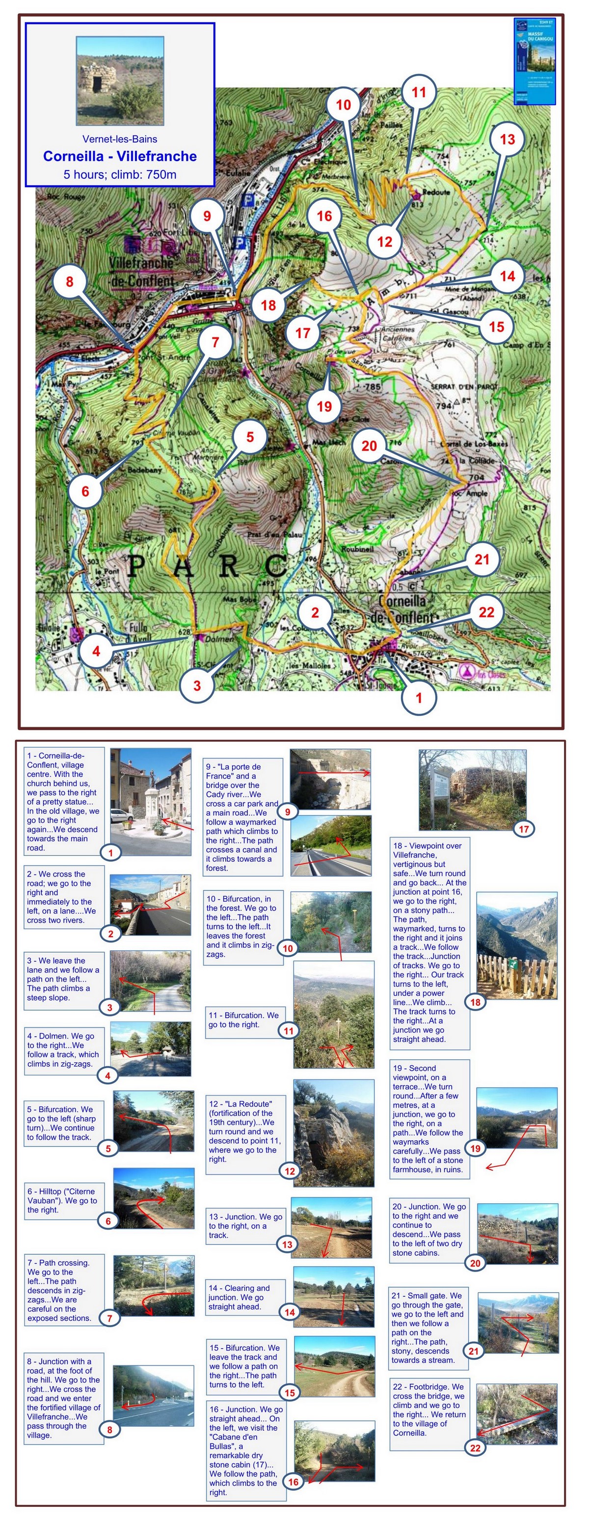
5½ hours; climb: 750m
A fairly hard walk in the hills between Corneilla and the medieval fortified town of Villefranche. Along the route, there are excellent viewpoints and interesting ancient monuments.
Please note (May 2026): a few months ago, the footbridge over a stream at point 23 was damaged during storms. It remains partially out of repair. But many walkers clearly find that it is possible to cross the bridge without great difficulty in dry conditions. However, it may be unwise to attempt a crossing during and soon after rainfall. If you want to avoid the footbridge, the walk from Corneilla up to Citerne Vauban (point 6) and back (2.5 hours), and the walk from Villefranche up to La Redoute (point 12) and back (2.5 hours), are each worth doing in their own right.
1 - Corneilla-de-Conflent, village centre. With the church behind us, we pass to the right of a pretty statue... In the old village, we go to the right again... We descend towards the main road.
2 - We cross the road; we descend a staircase to a lane... We follow the lane ahead... We cross two rivers.
3 - We leave the lane and we follow a path on the left... The path climbs a steep slope.
4 - Dolmen. We go to the right... We follow a track, which climbs in zig-zags.
5 - Bifurcation. We go to the left (sharp turn)... We continue to follow the track.
6 - Hilltop ('Citerne Vauban'). We go to the right.
7 - Path crossing. We go to the left... The path descends in zig-zags... We are careful on the exposed sections.
8 - Junction with a road, at the foot of the hill. We go to the right... We cross the road and we enter the fortified village of Villefranche... We pass through the village.
9 - 'La porte de France' and a bridge over the Cady river... We cross a car park and a main road... We follow a waymarked path which climbs to the right... The path crosses a canal and it climbs towards a forest.
10 - Bifurcation, in the forest. We go to the left... The path turns to the left... It leaves the forest and it climbs in zig-zags.
11 - Bifurcation. We go to the right.
12 - 'La Redoute' (fortification of the 19th century)... We turn round and we descend to point 11, where we go to the right.
13 - Junction. We go to the right, on a track.
14 - Clearing and junction. We go straight ahead.
15 - Bifurcation. We leave the track and we follow a path on the right... The path turns to the left.
16 - Junction. We go straight ahead... On the left, we visit the 'Cabane d'en Bullas', a remarkable dry stone cabin (17)... We follow the path, which climbs to the right.
18 - Viewpoint over Villefranche, vertiginous but safe... We turn round and go back... At the junction at point 16, we go to the right, on a stony path...The path, waymarked, turns to the right and it joins a track... We follow the track... Junction of tracks. We go to the right... Our track turns to the left, under a power line... We climb... The track turns to the right... At a junction we go straight ahead.
19 - Second viewpoint, on a terrace... We turn round... After a hundred metres, at the junction, we go to the right, on a path...There are occasional yellow waymarks.
20 - Bifurcation, just before a small embankment. We go to the right and we follow a path which descends...We pass some ruined farm buildings.
21 - Junction. We go to the right and we continue to descend... The path follows a sunken lane.
22 - Open area. We go straight ahead. The path continues to descend...The path enters woodland; it becomes stony; and it descends towards a stream.
23 - Footbridge. We cross the bridge, we climb and we go to the right... We return to the village of Corneilla, by the church.
2025