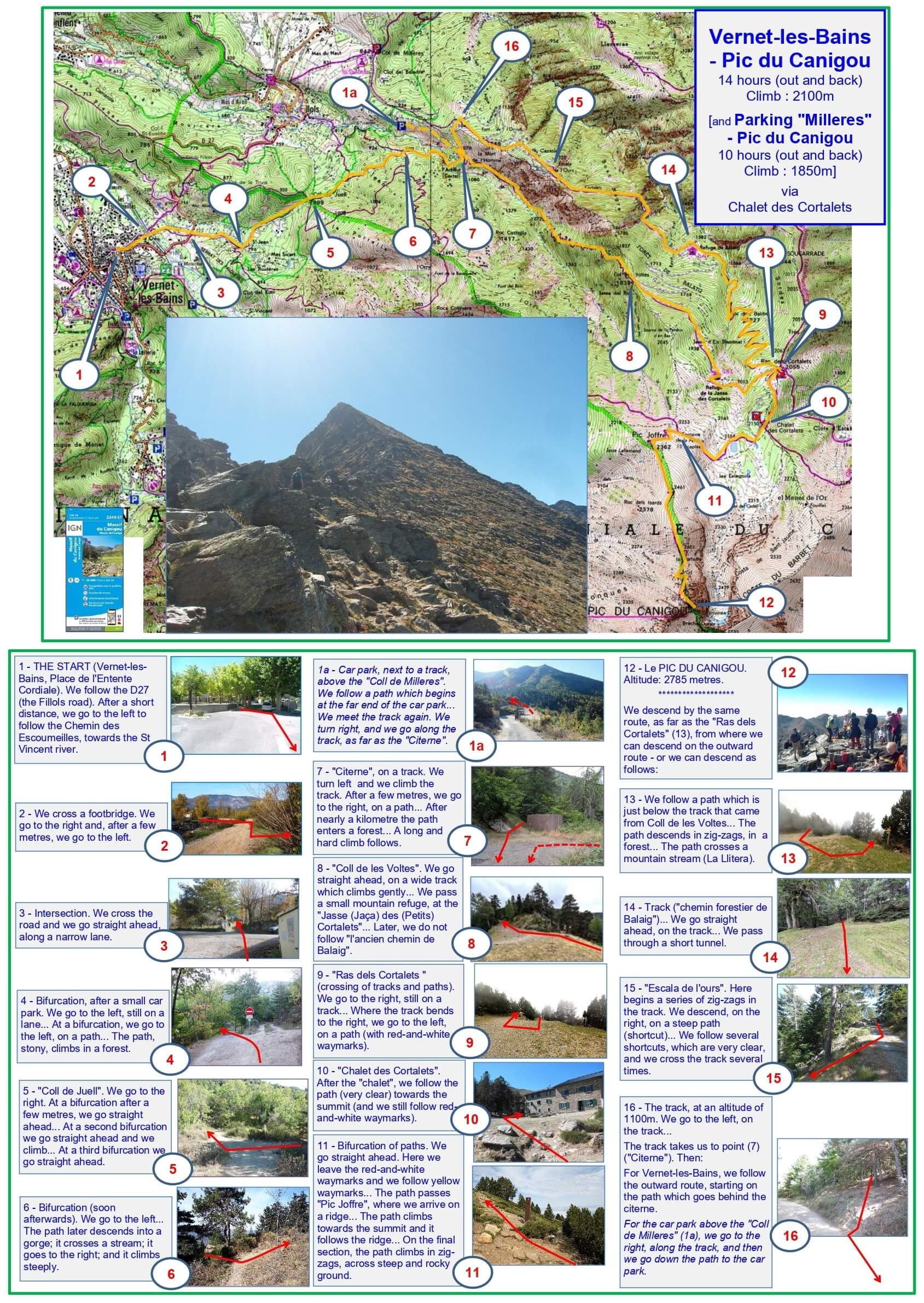
14 hours (out and back) (or 10 hours); climb: 2100m (or 1850m)
A classic route between Vernet-les-Bains and Canigou. Most walkers stay overnight at Cortalets on the ascent, then climb to Canigou and return to Vernet the next day, perhaps via Bonne-Aigue. Alternatively, it is possible to start above Fillols and walk to the summit and back in one day.
1 - THE START (Vernet-les-Bains, Place de l'Entente Cordiale). We follow the D27 (the Fillols road). After a short distance, we go to the left to follow the Chemin des Escoumeilles, towards the St Vincent river.
2 - We cross a footbridge. We go to the right and, after a few metres, we go to the left.
3 - Intersection. We cross the road and we go straight ahead, along a narrow lane.
4 - Bifurcation, after a small car park. We go to the left, still on a lane... At a bifurcation, we go to the left, on a path... The path, stony, climbs in a forest.
5 - 'Coll de Juell'. We go to the right. At a bifurcation after a few metres, we go straight ahead... At a second bifurcation we go straight ahead and we climb... At a third bifurcation we go straight ahead.
6 - Bifurcation (soon afterwards). We go to the left... The path later descends into a gorge; it crosses a stream; it goes to the right; and it climbs steeply.
1a - Car park, next to a track above the 'Coll de Milleres'. We follow a path which begins at the far end of the car park... We meet the track again. We turn right, along the track, as far as the 'Citerne'.
7 - 'Citerne', on a track. We turn left and we climb the track. After a few metres, we go to the right, on a path... After nearly a kilometre the path enters a forest... A long and hard climb follows.
8 - 'Coll de les Voltes'. We go straight ahead, on a wide track which climbs gently... We pass a small mountain refuge, at the 'Jasse (Jaça) des (Petits) Cortalets'... Later, we do not follow 'l'ancien chemin de Balaig'.
9 - 'Ras dels Cortalets' (crossing of tracks and paths). We go to the right, still on a track... Where the track bends to the right, we go to the left, on a path (with red-and-white waymarks).
10 - 'Chalet des Cortalets'. After the 'chalet', we follow the path, which is very clear, towards the summit (and we still follow red-and-white waymarks).
11 - Bifurcation of paths. We go straight ahead. Here we leave the red-and-white waymarks and we follow yellow waymarks... The path passes 'Pic Joffre', where we arrive on a ridge... The path climbs towards the summit and it follows the ridge... On the final section, the path climbs in zig-zags, across steep and rocky ground.
12 - The PIC DU CANIGOU. Altitude: 2785 metres.
We descend by the same route, as far as the 'Ras dels Cortalets' (13).
13 - 'Ras dels Cortalets'. We can descend on the outward route, or we can descend as follows:
13 - We follow a path which is just below the track that came from Coll de les Voltes... The path descends in zig-zags, in a forest... The path crosses a mountain stream (La Llitera).
14 - Track ('chemin forestier de Balaig'). We go straight ahead, on the track... We pass through a short tunnel.
15 - 'Escala de l'Ours'. Here begins a series of zig-zags in the track. We descend, on the right, on a steep path (shortcut)... We follow several shortcuts, which are very clear, and we cross the track several times.
16 - The track, at an altitude of 1100m. We go to the left, on the track... The track takes us to point (7) ('Citerne'). Then:
For Vernet-les-Bains, we follow the outward route, starting on the path which goes behind the citerne.
For the car park above the 'Coll de Milleres' (1a), we go to the right, along the track, and then we go down the path to the car park.
2024